IMAGES TAKEN NEAR TO
Roebuck Street, BARNSLEY, S73 0JX
Introduction
This page details the photographs taken nearby to Roebuck Street, S73 0JX by members of the Geograph project.
The Geograph project started in 2005 with the aim of publishing, organising and preserving representative images for every square kilometre of Great Britain, Ireland and the Isle of Man.

There are currently over 7.5m images from over14,400 individuals and you can help contribute to the project by visiting https://www.geograph.org.uk
Image Map
Images are licensed for reuse under creativecommons.org/licenses/by-sa/2.0
Notes
- Clicking on the map will re-center to the selected point.
- The higher the marker number, the further away the image location is from the centre of the postcode.
Image Listing (8 Images Found)
Images are licensed for reuse under creativecommons.org/licenses/by-sa/2.0
Image
Details
Distance
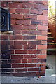
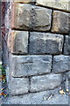
1

Benchmark on #8 Kings Road
Ordnance Survey cut mark benchmark described on the Bench Mark Database at http://www.bench-marks.org.uk/bm39681
Image: © Roger Templeman
Taken: 28 Sep 2011
0.20 miles
2
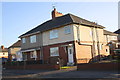
#8 Kings Road
There is an OS benchmark Image on the side front corner of the house
Image: © Roger Templeman
Taken: 28 Sep 2011
0.20 miles
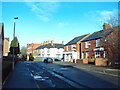
3

Wombwell - former swimming baths
On Collindridge Road.
Image: © Dave Bevis
Taken: 31 May 2013
0.21 miles
5
Benchmark on #29 Hough Lane
Ordnance Survey cut mark benchmark described on the Bench Mark Database at http://www.bench-marks.org.uk/bm39680
Image: © Roger Templeman
Taken: 28 Sep 2011
0.23 miles
7
Benchmark on wall next to #93 Hough Lane
Ordnance Survey cut mark benchmark described on the Bench Mark Database at http://www.bench-marks.org.uk/bm39677
Image: © Roger Templeman
Taken: 28 Sep 2011
0.25 miles
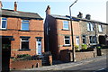
8
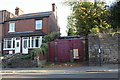
#93 Hough Lane, lockup and benchmarked wall
The OS benchmark Image is between the bus stop sign and left hand end of the wall.
Image: © Roger Templeman
Taken: 28 Sep 2011
0.25 miles