IMAGES TAKEN NEAR TO
Park Street, S73 0FG
Introduction
This page details the photographs taken nearby to Park Street, S73 0FG by members of the Geograph project.
The Geograph project started in 2005 with the aim of publishing, organising and preserving representative images for every square kilometre of Great Britain, Ireland and the Isle of Man.

There are currently over 7.5m images from over14,400 individuals and you can help contribute to the project by visiting https://www.geograph.org.uk
Image Map
Images are licensed for reuse under creativecommons.org/licenses/by-sa/2.0
Notes
- Clicking on the map will re-center to the selected point.
- The higher the marker number, the further away the image location is from the centre of the postcode.
Image Listing (54 Images Found)
Images are licensed for reuse under creativecommons.org/licenses/by-sa/2.0
Image
Details
Distance
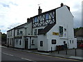
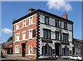
2
Wombwell - The Anglers Rest
On Park Street.
Image: © Dave Bevis
Taken: 31 May 2013
0.04 miles
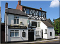
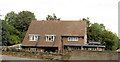
5
Wombwell - Last Orders
Pub on Park Street.
Image: © Dave Bevis
Taken: 31 May 2013
0.06 miles
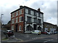
6
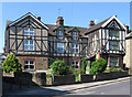
Wombwell - The Old Homestead
On Park Street.
Image: © Dave Bevis
Taken: 31 May 2013
0.08 miles
8
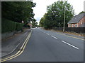
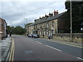
Park Street
Heading north west into Wombwell.
Image: © JThomas
Taken: 27 Sep 2014
0.13 miles
9
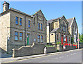
Wombwell - buildings on south side of Park Street
Image: © Dave Bevis
Taken: 31 May 2013
0.14 miles
10
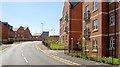
New apartments.
This new road has rejoined the communities of Darfield and Wombwell without the need for a substantial detour.
Image: © Steve Fareham
Taken: 24 Aug 2007
0.15 miles