IMAGES TAKEN NEAR TO
Haverhill Grove, BARNSLEY, S73 0DH
Introduction
This page details the photographs taken nearby to Haverhill Grove, S73 0DH by members of the Geograph project.
The Geograph project started in 2005 with the aim of publishing, organising and preserving representative images for every square kilometre of Great Britain, Ireland and the Isle of Man.

There are currently over 7.5m images from over14,400 individuals and you can help contribute to the project by visiting https://www.geograph.org.uk
Image Map
Images are licensed for reuse under creativecommons.org/licenses/by-sa/2.0
Notes
- Clicking on the map will re-center to the selected point.
- The higher the marker number, the further away the image location is from the centre of the postcode.
Image Listing (49 Images Found)
Images are licensed for reuse under creativecommons.org/licenses/by-sa/2.0
Image
Details
Distance
1
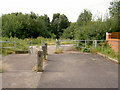
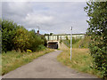
Access point to Trans Pennine Trail.
On what was Wombwell railway station.
Image: © Steve Fareham
Taken: 17 Aug 2007
0.04 miles
2
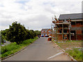
New houses on what was the road to Wombwell railway station.
Wombwell had 2 stations here and 1 mile north named Wombwell West.
Image: © Steve Fareham
Taken: 17 Aug 2007
0.07 miles
3
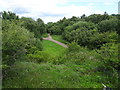
Wombwell Central railway station (site), Yorkshire
Opened in 1851 by the South Yorkshire Railway, later part of the Manchester Sheffield & Lincolnshire Railway on the line from Doncaster to Barnsley, this station closed to passengers in 1959.
View south east along the track-bed towards Wath Central and Doncaster. The 2 parallel platforms and station building were to the left of the image. The footpath to the right runs under the road using the under-bridge once used by the freight lines.
Image: © Nigel Thompson
Taken: 11 Jul 2020
0.09 miles
4
Stoneyford Road bridge over Trans Pennine Trail.
Image: © Steve Fareham
Taken: 17 Aug 2007
0.10 miles
6
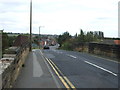
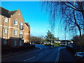
Station Road (B6906)
Heading north east over disused railway bridge.
Image: © JThomas
Taken: 27 Sep 2014
0.12 miles
7
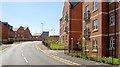
New apartments.
This new road has rejoined the communities of Darfield and Wombwell without the need for a substantial detour.
Image: © Steve Fareham
Taken: 24 Aug 2007
0.15 miles
8
North end of Mayflower Way, Wombwell
Approaching the roundabout where the A633 crosses Station Road.
Image: © Richard Vince
Taken: 6 Jan 2024
0.15 miles
9
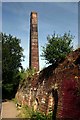
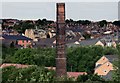
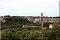
Old Brickyard Chimney Wombwell
This old chimney was part of the old Wombwell Brickwork Company. As of July 2010, the chimney and surrounding structures are due to be demolished.
Image: © Jeff Pearson
Taken: 24 Jul 2010
0.15 miles