IMAGES TAKEN NEAR TO
The Rise, BARNSLEY, S72 9LN
Introduction
This page details the photographs taken nearby to The Rise, S72 9LN by members of the Geograph project.
The Geograph project started in 2005 with the aim of publishing, organising and preserving representative images for every square kilometre of Great Britain, Ireland and the Isle of Man.

There are currently over 7.5m images from over14,400 individuals and you can help contribute to the project by visiting https://www.geograph.org.uk
Image Map
Images are licensed for reuse under creativecommons.org/licenses/by-sa/2.0
Notes
- Clicking on the map will re-center to the selected point.
- The higher the marker number, the further away the image location is from the centre of the postcode.
Image Listing (71 Images Found)
Images are licensed for reuse under creativecommons.org/licenses/by-sa/2.0
Image
Details
Distance
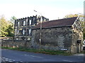
1
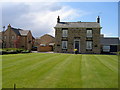
Violet Farm House
All the land around the house was sold in recent years to provide space for a cramped and faceless modern housing estate.
Image: © Carol Rose
Taken: 18 May 2007
0.01 miles
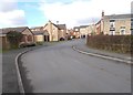
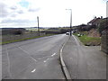
2
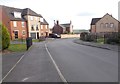
The Rise - looking towards Brierley Road
Image: © Betty Longbottom
Taken: 24 Feb 2017
0.02 miles
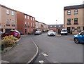
3
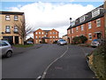
Bretton Close - viewed from The Rise
Image: © Betty Longbottom
Taken: 24 Feb 2017
0.04 miles
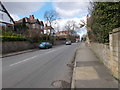
4
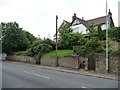
Semis with a view, Brierley
High above the west side of Church Street.
Image: © Christine Johnstone
Taken: 1 Aug 2012
0.04 miles
6
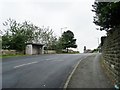
Brierley Road bus stop and shelter
South of the junction with Church Street.
Image: © Christine Johnstone
Taken: 1 Aug 2012
0.04 miles
7
Monument Drive - viewed from The Rise
Image: © Betty Longbottom
Taken: 24 Feb 2017
0.05 miles
10
Brierley Road - viewed from The Rise
Image: © Betty Longbottom
Taken: 24 Feb 2017
0.06 miles