IMAGES TAKEN NEAR TO
Hall Gardens, BARNSLEY, S72 9FF
Introduction
This page details the photographs taken nearby to Hall Gardens, S72 9FF by members of the Geograph project.
The Geograph project started in 2005 with the aim of publishing, organising and preserving representative images for every square kilometre of Great Britain, Ireland and the Isle of Man.

There are currently over 7.5m images from over14,400 individuals and you can help contribute to the project by visiting https://www.geograph.org.uk
Image Map
Images are licensed for reuse under creativecommons.org/licenses/by-sa/2.0
Notes
- Clicking on the map will re-center to the selected point.
- The higher the marker number, the further away the image location is from the centre of the postcode.
Image Listing (102 Images Found)
Images are licensed for reuse under creativecommons.org/licenses/by-sa/2.0
Image
Details
Distance
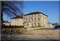
3
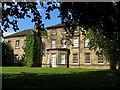
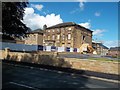
Brierley Hall
Used as council offices for many years.
Image: © Carol Rose
Taken: 18 May 2007
0.03 miles
6
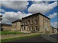
Brierley Hall, Brierley
Now featured in a modern housing development.
Image: © Neil Theasby
Taken: 4 Aug 2017
0.04 miles
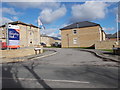
7
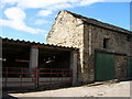
Farm buildings, Hall Farm
The farm opens directly onto Church Street.
Image: © Carol Rose
Taken: 18 May 2007
0.04 miles
9
Brierley Hall
Grade II listed Hall which is currently now part of a new housing development. A 1960s brick extension which was tacked onto the near wall has been removed.
Image: © Jonathan Clitheroe
Taken: 28 Aug 2015
0.05 miles
10
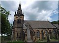
War memorial and St. Paul's Church Brierley
Image: © Steve Fareham
Taken: 14 Jun 2009
0.06 miles