IMAGES TAKEN NEAR TO
Common Road, BARNSLEY, S72 9ET
Introduction
This page details the photographs taken nearby to Common Road, S72 9ET by members of the Geograph project.
The Geograph project started in 2005 with the aim of publishing, organising and preserving representative images for every square kilometre of Great Britain, Ireland and the Isle of Man.

There are currently over 7.5m images from over14,400 individuals and you can help contribute to the project by visiting https://www.geograph.org.uk
Image Map
Images are licensed for reuse under creativecommons.org/licenses/by-sa/2.0
Notes
- Clicking on the map will re-center to the selected point.
- The higher the marker number, the further away the image location is from the centre of the postcode.
Image Listing (9 Images Found)
Images are licensed for reuse under creativecommons.org/licenses/by-sa/2.0
Image
Details
Distance
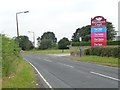
2
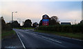
Entrance to Burntwood Court
Hotel and sports club on Brierley Common.
Image: © Steve Fareham
Taken: 3 Nov 2007
0.11 miles
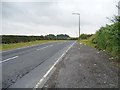
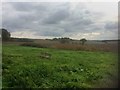
3
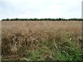
Oil seed rape crop, south of Common Road
The hedge on the horizon marks the route of a restricted byway.
Image: © Christine Johnstone
Taken: 1 Aug 2012
0.11 miles
6
Bus stop at Burntwood Court, Common Road
Blue bus stops mean this is South Yorkshire.
Image: © Christine Johnstone
Taken: 1 Aug 2012
0.11 miles
7
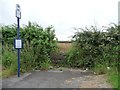
Bus stop at a blocked field entrance
On the south side of Common Road.
Image: © Christine Johnstone
Taken: 1 Aug 2012
0.11 miles
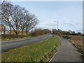
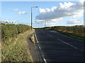
8
Layby on Common Road
Looking east towards Brierley Gap.
Image: © Christine Johnstone
Taken: 1 Aug 2012
0.13 miles
9
Spot the bench
View from Brierley towards Houghton Common.
Image: © Steve Fareham
Taken: 21 Oct 2016
0.14 miles