IMAGES TAKEN NEAR TO
Park View, BARNSLEY, S72 9EN
Introduction
This page details the photographs taken nearby to Park View, S72 9EN by members of the Geograph project.
The Geograph project started in 2005 with the aim of publishing, organising and preserving representative images for every square kilometre of Great Britain, Ireland and the Isle of Man.

There are currently over 7.5m images from over14,400 individuals and you can help contribute to the project by visiting https://www.geograph.org.uk
Image Map
Images are licensed for reuse under creativecommons.org/licenses/by-sa/2.0
Notes
- Clicking on the map will re-center to the selected point.
- The higher the marker number, the further away the image location is from the centre of the postcode.
Image Listing (31 Images Found)
Images are licensed for reuse under creativecommons.org/licenses/by-sa/2.0
Image
Details
Distance
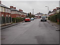
1
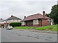
Bungalows in Park View, Brierley
Both the bungalows and the houses are semi-detached.
Image: © Christine Johnstone
Taken: 1 Aug 2012
0.02 miles
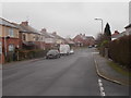
2
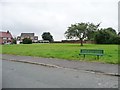
Open space at Pudding Hill
Between Park View and Common Road, at the eastern edge of Brierley.
Image: © Christine Johnstone
Taken: 1 Aug 2012
0.03 miles
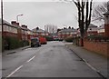
4
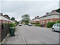
Park Road, Brierley
Running between Park View and Park Avenue.
Image: © Christine Johnstone
Taken: 1 Aug 2012
0.07 miles
5
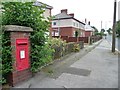
Wall letter box, Brierley
On the north side of Common Road, near Park Avenue.
Image: © Christine Johnstone
Taken: 1 Aug 2012
0.08 miles
6
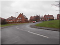
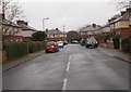
Park View - viewed from Park Avenue
Image: © Betty Longbottom
Taken: 3 Mar 2017
0.08 miles
10
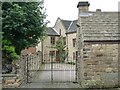
Eastern entrance to Elms Farm, Brierley
The farmhouse no longer has an agricultural use.
Image: © Christine Johnstone
Taken: 1 Aug 2012
0.10 miles