IMAGES TAKEN NEAR TO
High Well Hill Lane, BARNSLEY, S72 9DF
Introduction
This page details the photographs taken nearby to High Well Hill Lane, S72 9DF by members of the Geograph project.
The Geograph project started in 2005 with the aim of publishing, organising and preserving representative images for every square kilometre of Great Britain, Ireland and the Isle of Man.

There are currently over 7.5m images from over14,400 individuals and you can help contribute to the project by visiting https://www.geograph.org.uk
Image Map
Images are licensed for reuse under creativecommons.org/licenses/by-sa/2.0
Notes
- Clicking on the map will re-center to the selected point.
- The higher the marker number, the further away the image location is from the centre of the postcode.
Image Listing (3 Images Found)
Images are licensed for reuse under creativecommons.org/licenses/by-sa/2.0
Image
Details
Distance
1
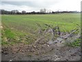
Tracks in a greening field
From the junction of Hope Street and Brier Lane.
Image: © Christine Johnstone
Taken: 16 Feb 2011
0.20 miles
2
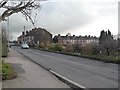
Hope Street
A rural terrace built for coal mining families.
Image: © Christine Johnstone
Taken: 16 Feb 2011
0.21 miles
3
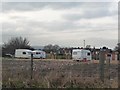
Gated caravan site
Near a former colliery line, with signs of demolished buildings.
Image: © Christine Johnstone
Taken: 16 Feb 2011
0.23 miles