IMAGES TAKEN NEAR TO
Main Street, BARNSLEY, S72 9AA
Introduction
This page details the photographs taken nearby to Main Street, S72 9AA by members of the Geograph project.
The Geograph project started in 2005 with the aim of publishing, organising and preserving representative images for every square kilometre of Great Britain, Ireland and the Isle of Man.

There are currently over 7.5m images from over14,400 individuals and you can help contribute to the project by visiting https://www.geograph.org.uk
Image Map
Images are licensed for reuse under creativecommons.org/licenses/by-sa/2.0
Notes
- Clicking on the map will re-center to the selected point.
- The higher the marker number, the further away the image location is from the centre of the postcode.
Image Listing (32 Images Found)
Images are licensed for reuse under creativecommons.org/licenses/by-sa/2.0
Image
Details
Distance
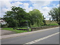
1
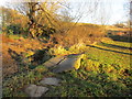
Simple footbridge, South Hiendley Common
The bridge consists of two parallel slabs of stone.
Image: © Jonathan Thacker
Taken: 5 Jan 2017
0.02 miles

4
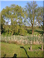
Village duck pond
Which is rather clogged with bulrushes. Beyond the tree is South Hiendley Common.
Image: © Carol Rose
Taken: 28 Apr 2007
0.05 miles
5
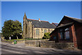
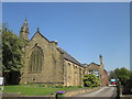
Methodist Church on Main Street, South Hiendley
Image: © Ian S
Taken: 27 Feb 2019
0.05 miles