IMAGES TAKEN NEAR TO
Storrs Mill Lane, BARNSLEY, S72 8SQ
Introduction
This page details the photographs taken nearby to Storrs Mill Lane, S72 8SQ by members of the Geograph project.
The Geograph project started in 2005 with the aim of publishing, organising and preserving representative images for every square kilometre of Great Britain, Ireland and the Isle of Man.

There are currently over 7.5m images from over14,400 individuals and you can help contribute to the project by visiting https://www.geograph.org.uk
Image Map
Images are licensed for reuse under creativecommons.org/licenses/by-sa/2.0
Notes
- Clicking on the map will re-center to the selected point.
- The higher the marker number, the further away the image location is from the centre of the postcode.
Image Listing (12 Images Found)
Images are licensed for reuse under creativecommons.org/licenses/by-sa/2.0
Image
Details
Distance
1
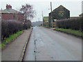
Storrs Mill Farm
Farm buildings to the right and private houses to the left.
Image: © Richard Spencer
Taken: 5 Feb 2006
0.04 miles
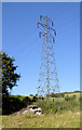
6

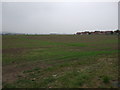
Cudworth Common
Close to the village of Cudworth in South Yorkshire this was once an area used for mining of coal. The wind turbine has been erected in the last few years.
Image: © Tom Curtis
Taken: 10 Oct 2019
0.19 miles
7
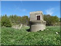
Structure south of Cudworth
I am not sure what this odd riverside structure is all about. Possibly to do with river management or maybe connected with a redundant coal mine.
Image: © Neil Theasby
Taken: 26 Apr 2015
0.20 miles
8
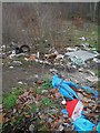
I'd like to teach the world not to drop their rubbish here!
A coca cola Christmas hat adorns this local fly tip.
Image: © Steve Fareham
Taken: 24 Dec 2011
0.20 miles
10
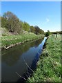
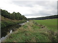
The River Dearne south of Cudworth
The footpath the maps show hugging this loop in the river does not appear to exist. It certainly isn't regularly trodden. Perhaps the course of the path was altered to miss out the loop on which you find this canal-like straight section of The River Dearne.
Image: © Neil Theasby
Taken: 26 Apr 2015
0.23 miles