IMAGES TAKEN NEAR TO
Pleasant View, BARNSLEY, S72 8SA
Introduction
This page details the photographs taken nearby to Pleasant View, S72 8SA by members of the Geograph project.
The Geograph project started in 2005 with the aim of publishing, organising and preserving representative images for every square kilometre of Great Britain, Ireland and the Isle of Man.

There are currently over 7.5m images from over14,400 individuals and you can help contribute to the project by visiting https://www.geograph.org.uk
Image Map
Images are licensed for reuse under creativecommons.org/licenses/by-sa/2.0
Notes
- Clicking on the map will re-center to the selected point.
- The higher the marker number, the further away the image location is from the centre of the postcode.
Image Listing (5 Images Found)
Images are licensed for reuse under creativecommons.org/licenses/by-sa/2.0
Image
Details
Distance
1
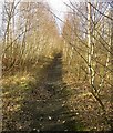
The disused railway line near Cudworth
Image: © Steve Fareham
Taken: 1 Feb 2009
0.21 miles
2
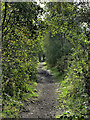
Footpath alongside disused Railway Line
Following route of old railway line through Cudworth near Barnsley South Yorkshire England.
https://www.flickr.com/photos/tomcurtisvideos/
Image: © Tom Curtis
Taken: 6 Sep 2012
0.21 miles
3
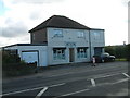
Darfield Road Stores, Darfield Road, Cudworth
This shop once had views out of its back windows across the old Grimethorpe Colliery. The shop lost considerable trade when the colliery closed.
Image: © John Orchard
Taken: 7 Sep 2010
0.22 miles
4
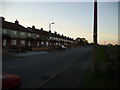
1st houses
These are the 1st houses as you get to Cudworth from Darfield on Darfield Rd.
Image: © John Douglas
Taken: 7 Nov 2006
0.22 miles
5
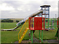
Playtime in Cudworth.
Reclaimed spoil heap in the background.
Image: © Steve Fareham
Taken: 12 Aug 2007
0.23 miles