IMAGES TAKEN NEAR TO
Brierley Road, BARNSLEY, S72 8QW
Introduction
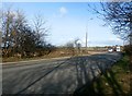
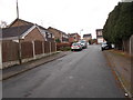
This page details the photographs taken nearby to Brierley Road, S72 8QW by members of the Geograph project.
The Geograph project started in 2005 with the aim of publishing, organising and preserving representative images for every square kilometre of Great Britain, Ireland and the Isle of Man.

There are currently over 7.5m images from over14,400 individuals and you can help contribute to the project by visiting https://www.geograph.org.uk
Image Map
Images are licensed for reuse under creativecommons.org/licenses/by-sa/2.0
Notes
- Clicking on the map will re-center to the selected point.
- The higher the marker number, the further away the image location is from the centre of the postcode.
Image Listing (4 Images Found)
Images are licensed for reuse under creativecommons.org/licenses/by-sa/2.0
Image
Details
Distance

2
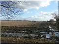
Ploughed Field Between Shafton and Brierley
A saturated field corner by the A628 Road, which is offset by expansive views in the direction of Grimethorpe.
Image: © Jonathan Clitheroe
Taken: 24 Feb 2017
0.12 miles