IMAGES TAKEN NEAR TO
Greenside, BARNSLEY, S72 8PL
Introduction
This page details the photographs taken nearby to Greenside, S72 8PL by members of the Geograph project.
The Geograph project started in 2005 with the aim of publishing, organising and preserving representative images for every square kilometre of Great Britain, Ireland and the Isle of Man.

There are currently over 7.5m images from over14,400 individuals and you can help contribute to the project by visiting https://www.geograph.org.uk
Image Map
Images are licensed for reuse under creativecommons.org/licenses/by-sa/2.0
Notes
- Clicking on the map will re-center to the selected point.
- The higher the marker number, the further away the image location is from the centre of the postcode.
Image Listing (27 Images Found)
Images are licensed for reuse under creativecommons.org/licenses/by-sa/2.0
Image
Details
Distance
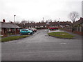
1
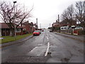
Greenside Estate - Sandybridge Lane
Image: © Betty Longbottom
Taken: 10 Feb 2017
0.05 miles

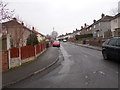
5
The Singing Man - Sandybridge Lane
Image: © Betty Longbottom
Taken: 10 Feb 2017
0.08 miles
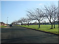
6
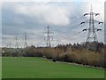
Power lines above, trees below
Along the line of Sandybridge Dike.
Image: © Christine Johnstone
Taken: 16 Feb 2011
0.10 miles
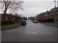
7
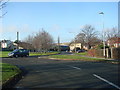
Looking from Redthorn Way, down Sandybridge Lane, towards Felixkirk
Image: © Bill Henderson
Taken: 29 Nov 2006
0.10 miles
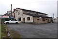
10

Playground on The Green Shafton
From Redthorne Way.
Image: © Steve Fareham
Taken: 26 Apr 2008
0.14 miles