IMAGES TAKEN NEAR TO
Dog Hill Drive, BARNSLEY, S72 8NW
Introduction
This page details the photographs taken nearby to Dog Hill Drive, S72 8NW by members of the Geograph project.
The Geograph project started in 2005 with the aim of publishing, organising and preserving representative images for every square kilometre of Great Britain, Ireland and the Isle of Man.

There are currently over 7.5m images from over14,400 individuals and you can help contribute to the project by visiting https://www.geograph.org.uk
Image Map
Images are licensed for reuse under creativecommons.org/licenses/by-sa/2.0
Notes
- Clicking on the map will re-center to the selected point.
- The higher the marker number, the further away the image location is from the centre of the postcode.
Image Listing (45 Images Found)
Images are licensed for reuse under creativecommons.org/licenses/by-sa/2.0
Image
Details
Distance
6
Electricity Substation No 22540 - Dog Hill
Image: © Betty Longbottom
Taken: 10 Feb 2017
0.09 miles

8
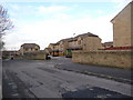
Hawthorne Street - viewed from Ashwell Close
Image: © Betty Longbottom
Taken: 10 Feb 2017
0.10 miles
10
Holly Farm, Shafton
New houses on the east side of Hawthorne Street.
Image: © Christine Johnstone
Taken: 16 Feb 2011
0.11 miles