IMAGES TAKEN NEAR TO
Cadwell Close, BARNSLEY, S72 8ND
Introduction
This page details the photographs taken nearby to Cadwell Close, S72 8ND by members of the Geograph project.
The Geograph project started in 2005 with the aim of publishing, organising and preserving representative images for every square kilometre of Great Britain, Ireland and the Isle of Man.

There are currently over 7.5m images from over14,400 individuals and you can help contribute to the project by visiting https://www.geograph.org.uk
Image Map
Images are licensed for reuse under creativecommons.org/licenses/by-sa/2.0
Notes
- Clicking on the map will re-center to the selected point.
- The higher the marker number, the further away the image location is from the centre of the postcode.
Image Listing (5 Images Found)
Images are licensed for reuse under creativecommons.org/licenses/by-sa/2.0
Image
Details
Distance
1
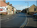
Barnsley Road, Cudworth A628 looking north
This is the main road through Cudworth (Upper Cudworth) towards Shafton. The new Cudworth and West Green by-pass has relieved this road of some traffic. The photograph has been taken opposite the old Rose Tree Avenue medical practices and is outside Steve Dootson's garage.
Image: © John Orchard
Taken: 7 Sep 2010
0.18 miles

3
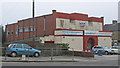
Cudworth - former Rock Cinema
On Market Place.
Image: © Dave Bevis
Taken: 2 Apr 2014
0.22 miles
5
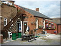
The Cudworth Industrial Social Club
This Sam Smith's club is known locally as the Sawdust Club.
Image: © Ian S
Taken: 18 Aug 2012
0.25 miles