IMAGES TAKEN NEAR TO
Ring Farm View, BARNSLEY, S72 8FT
Introduction
This page details the photographs taken nearby to Ring Farm View, S72 8FT by members of the Geograph project.
The Geograph project started in 2005 with the aim of publishing, organising and preserving representative images for every square kilometre of Great Britain, Ireland and the Isle of Man.

There are currently over 7.5m images from over14,400 individuals and you can help contribute to the project by visiting https://www.geograph.org.uk
Image Map
Images are licensed for reuse under creativecommons.org/licenses/by-sa/2.0
Notes
- Clicking on the map will re-center to the selected point.
- The higher the marker number, the further away the image location is from the centre of the postcode.
Image Listing (5 Images Found)
Images are licensed for reuse under creativecommons.org/licenses/by-sa/2.0
Image
Details
Distance
2
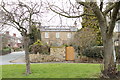
Low Cudworth
This house was once part of one of the farms on the manor. It was occupied at the start of the 20th century by Mr Harrison, a local pharmacist, and son of the stonemason and quarryman who worked the nearby quarries at Quarry Vale and the other quarries alongside White Cross Road.
The picture was taken with the Old Cudworth Green behind the camera.
Image: © John Orchard
Taken: 2 Jul 2012
0.17 miles
3
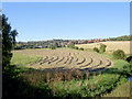
Low Cudworth
Looking towards Sycamore Farm and Poplar Farm
Image: © John Orchard
Taken: 2 Jul 2012
0.18 miles
4
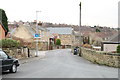
Sunny afternoon.
The building in the middle distance is the Police Horse stables.
Image: © Steve Fareham
Taken: 7 Sep 2007
0.19 miles
5
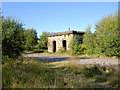
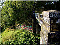
Water tank support from a bygone steam train age
Jon Webb suggests: Could this have been a support for a rectangular water tank used for providing water for steam engines? The building appears to be flat-topped and that could be a pipe sticking up? The ground floor would have been used as storage for railway equipment.
Image: © Steve Fareham
Taken: 7 Sep 2007
0.23 miles