IMAGES TAKEN NEAR TO
Royston Road, BARNSLEY, S72 8BP
Introduction
This page details the photographs taken nearby to Royston Road, S72 8BP by members of the Geograph project.
The Geograph project started in 2005 with the aim of publishing, organising and preserving representative images for every square kilometre of Great Britain, Ireland and the Isle of Man.

There are currently over 7.5m images from over14,400 individuals and you can help contribute to the project by visiting https://www.geograph.org.uk
Image Map
Images are licensed for reuse under creativecommons.org/licenses/by-sa/2.0
Notes
- Clicking on the map will re-center to the selected point.
- The higher the marker number, the further away the image location is from the centre of the postcode.
Image Listing (21 Images Found)
Images are licensed for reuse under creativecommons.org/licenses/by-sa/2.0
Image
Details
Distance
1
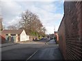
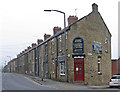
Crosby Street, Cudworth
Looking from Royston Road to Pontefract Road.
Image: © Christine Johnstone
Taken: 16 Feb 2011
0.05 miles
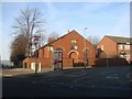
3

Cudworth - Wesleyan Reform Church
For an alternative view, please see Image
Image: © Dave Bevis
Taken: 2 Apr 2014
0.07 miles
4
Zion Wesley Reform Church, Upper Cudworth
Image: © Bill Henderson
Taken: 4 Feb 2007
0.07 miles
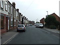
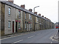
6
Cudworth - terraces on Pontefract Road
North of Charles Street junction.
Image: © Dave Bevis
Taken: 2 Apr 2014
0.09 miles
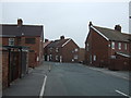
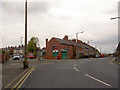
7
Cudworth - terraces on Pontefract Road
South of Kings Road junction.
Image: © Dave Bevis
Taken: 2 Apr 2014
0.09 miles

10
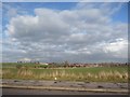
Big fields, big clouds
The view from Royston Road. The white houses on the distant hill are at Manor Farm, Shafton.
Image: © Christine Johnstone
Taken: 16 Feb 2011
0.10 miles