IMAGES TAKEN NEAR TO
Nancy Crescent, BARNSLEY, S72 7JN
Introduction
This page details the photographs taken nearby to Nancy Crescent, S72 7JN by members of the Geograph project.
The Geograph project started in 2005 with the aim of publishing, organising and preserving representative images for every square kilometre of Great Britain, Ireland and the Isle of Man.

There are currently over 7.5m images from over14,400 individuals and you can help contribute to the project by visiting https://www.geograph.org.uk
Image Map
Images are licensed for reuse under creativecommons.org/licenses/by-sa/2.0
Notes
- Clicking on the map will re-center to the selected point.
- The higher the marker number, the further away the image location is from the centre of the postcode.
Image Listing (12 Images Found)
Images are licensed for reuse under creativecommons.org/licenses/by-sa/2.0
Image
Details
Distance
4

The Red Rum public house
A Sam Smith's pub in Grimethorpe.
Image: © Ian S
Taken: 14 Jul 2012
0.13 miles
5

The Red Rum public house
A Sam Smith's public house in Grimethorpe
Image: © Ian S
Taken: 14 Jul 2012
0.13 miles
6

The Red Rum public house
A Sam Smith's pub in Grimethorpe.
Image: © Ian S
Taken: 14 Jul 2012
0.13 miles
7
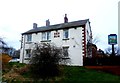
The Red Rum Public House in Grimethorpe
A Sam Smiths pub located on Cemetery Road. A well-kept local with lots of interesting old photos dotted around the walls.
Image: © Jonathan Clitheroe
Taken: 17 Mar 2017
0.13 miles
9
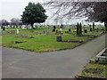
Grimethorpe Cemetery
Quiet we don't want to wake the dead.
Image: © Richard Spencer
Taken: 5 Feb 2006
0.19 miles
10
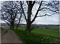
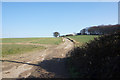
Daffodils at Brierly Lodge Farm
The Barnsley Boundary walk follows the track on the left down towards Grimethorpe. Much of the village is visiblefrom this vanatage point.
Image: © Jonathan Clitheroe
Taken: 17 Mar 2017
0.22 miles