IMAGES TAKEN NEAR TO
Clear View, BARNSLEY, S72 7HD
Introduction
This page details the photographs taken nearby to Clear View, S72 7HD by members of the Geograph project.
The Geograph project started in 2005 with the aim of publishing, organising and preserving representative images for every square kilometre of Great Britain, Ireland and the Isle of Man.

There are currently over 7.5m images from over14,400 individuals and you can help contribute to the project by visiting https://www.geograph.org.uk
Image Map
Images are licensed for reuse under creativecommons.org/licenses/by-sa/2.0
Notes
- Clicking on the map will re-center to the selected point.
- The higher the marker number, the further away the image location is from the centre of the postcode.
Image Listing (5 Images Found)
Images are licensed for reuse under creativecommons.org/licenses/by-sa/2.0
Image
Details
Distance
1
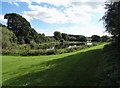
Fishing pond at The Dell - Grimethorpe Bottoms
Image: © Neil Theasby
Taken: 22 Sep 2016
0.10 miles
4
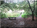
Footbridge and seat west of Tom Bank Wood
Image: © John Slater
Taken: 5 Oct 2013
0.25 miles
5
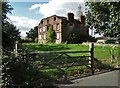
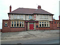
Grimethorpe Hall in September 2016
Built for Robert Seaton of Arksey in 1669, this noteworthy country house sits in a fine, elevated position. It has been sadly neglected for many years but it has some enthusiastic supporters. See https://grimethorpehall.wordpress.com/
Image: © Neil Theasby
Taken: 22 Sep 2016
0.25 miles