IMAGES TAKEN NEAR TO
Ferrymoor Way, BARNSLEY, S72 7BN
Introduction
This page details the photographs taken nearby to Ferrymoor Way, S72 7BN by members of the Geograph project.
The Geograph project started in 2005 with the aim of publishing, organising and preserving representative images for every square kilometre of Great Britain, Ireland and the Isle of Man.

There are currently over 7.5m images from over14,400 individuals and you can help contribute to the project by visiting https://www.geograph.org.uk
Image Map
Images are licensed for reuse under creativecommons.org/licenses/by-sa/2.0
Notes
- Clicking on the map will re-center to the selected point.
- The higher the marker number, the further away the image location is from the centre of the postcode.
Image Listing (10 Images Found)
Images are licensed for reuse under creativecommons.org/licenses/by-sa/2.0
Image
Details
Distance
2
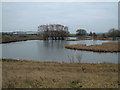
Pond
A public walking area runs round the pond in the old mining area.
Image: © Richard Spencer
Taken: 5 Feb 2006
0.05 miles

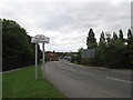
4
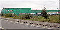
The Green Sash
UPVC window manufacturer Sash has a very green building at the bottom of Engine Lane Grimethorpe.
Image: © Steve Fareham
Taken: 14 Oct 2007
0.07 miles
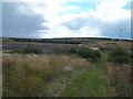
5

Ferrymoor Flash Grimethorpe
Nature Reserve close to the village of Grimethorpe South Yorkshire England.
Image: © Tom Curtis
Taken: 14 Jan 2017
0.11 miles
6
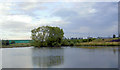
More in the regeneration of Grimethorpe.
Pond in front of the Sash UPVC factory.
Image: © Steve Fareham
Taken: 12 Aug 2007
0.11 miles
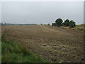

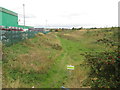
10
Site of Former Grimethorpe Colliery
Image: © Jonathan Clitheroe
Taken: 28 Aug 2015
0.21 miles