IMAGES TAKEN NEAR TO
Clayburn Road, BARNSLEY, S72 7BE
Introduction
This page details the photographs taken nearby to Clayburn Road, S72 7BE by members of the Geograph project.
The Geograph project started in 2005 with the aim of publishing, organising and preserving representative images for every square kilometre of Great Britain, Ireland and the Isle of Man.

There are currently over 7.5m images from over14,400 individuals and you can help contribute to the project by visiting https://www.geograph.org.uk
Image Map
Images are licensed for reuse under creativecommons.org/licenses/by-sa/2.0
Notes
- Clicking on the map will re-center to the selected point.
- The higher the marker number, the further away the image location is from the centre of the postcode.
Image Listing (7 Images Found)
Images are licensed for reuse under creativecommons.org/licenses/by-sa/2.0
Image
Details
Distance
1
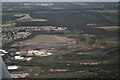
Carlton Main Brickworks SSSI, Grimethorpe: aerial 2022 (1)
Image: © Chris
Taken: 17 Apr 2022
0.18 miles
2
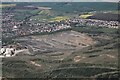
Carlton Main Brickworks SSSI, Grimethorpe: aerial 2022 (2)
Image: © Chris
Taken: 17 Apr 2022
0.18 miles
4

Night falls on the Grimethorpe by pass
On the right the ongoing remediation of the Grimethorpe colliery 'muck stack'.
Image: © Steve Fareham
Taken: 9 Jun 2008
0.21 miles
6
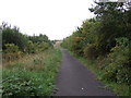
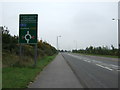
Cycle track beside the A6195
Heading south.
Image: © JThomas
Taken: 25 Sep 2013
0.23 miles
7
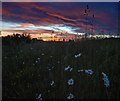
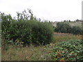
Roadside flora at Sunset
Ox eye daisies adjacent to the Grimethorpe bypass lay by.
Image: © Steve Fareham
Taken: 9 Jun 2008
0.23 miles