IMAGES TAKEN NEAR TO
Flat Lane, BARNSLEY, S72 0JB
Introduction
This page details the photographs taken nearby to Flat Lane, S72 0JB by members of the Geograph project.
The Geograph project started in 2005 with the aim of publishing, organising and preserving representative images for every square kilometre of Great Britain, Ireland and the Isle of Man.

There are currently over 7.5m images from over14,400 individuals and you can help contribute to the project by visiting https://www.geograph.org.uk
Image Map
Images are licensed for reuse under creativecommons.org/licenses/by-sa/2.0
Notes
- Clicking on the map will re-center to the selected point.
- The higher the marker number, the further away the image location is from the centre of the postcode.
Image Listing (23 Images Found)
Images are licensed for reuse under creativecommons.org/licenses/by-sa/2.0
Image
Details
Distance

3
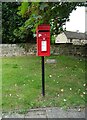
Elizabeth II postbox, Billingley
Postbox No. S72 81.
Image: © JThomas
Taken: 19 Sep 2022
0.07 miles
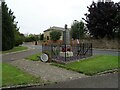

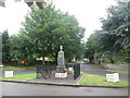
7
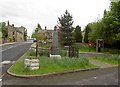
Billingley's first world war memorial
At the end of Chapel Lane.
Image: © Steve Fareham
Taken: 4 May 2009
0.09 miles
8

Methodist Chapel, Billingley
Erected by public subscription in 1818.
Image: © Neil Theasby
Taken: 21 May 2015
0.11 miles
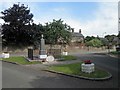
9
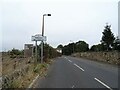
Entering Billingley on Billingley Green Lane
Image: © JThomas
Taken: 19 Sep 2022
0.12 miles
10
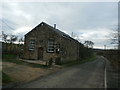
Methodist Chapel in Billingley
Chapel and former Sunday School which appears to be undergoing an overhaul at the time of posting.
Image: © Jonathan Clitheroe
Taken: 26 Nov 2015
0.12 miles