IMAGES TAKEN NEAR TO
Middlecliff Lane, BARNSLEY, S72 0HX
Introduction
This page details the photographs taken nearby to Middlecliff Lane, S72 0HX by members of the Geograph project.
The Geograph project started in 2005 with the aim of publishing, organising and preserving representative images for every square kilometre of Great Britain, Ireland and the Isle of Man.

There are currently over 7.5m images from over14,400 individuals and you can help contribute to the project by visiting https://www.geograph.org.uk
Image Map
Images are licensed for reuse under creativecommons.org/licenses/by-sa/2.0
Notes
- Clicking on the map will re-center to the selected point.
- The higher the marker number, the further away the image location is from the centre of the postcode.
Image Listing (12 Images Found)
Images are licensed for reuse under creativecommons.org/licenses/by-sa/2.0
Image
Details
Distance
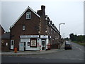
1
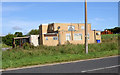
Middlecliffe (Plevna) working men's club.
Image: © Steve Fareham
Taken: 20 Aug 2007
0.01 miles
2
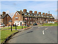
Plevna.
Middlecliffe was known locally as Plevna.
Image: © Steve Fareham
Taken: 20 Aug 2007
0.03 miles
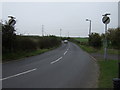
5
Oil pipeline marker
With a flash of poppies.
Image: © Steve Fareham
Taken: 12 Jun 2008
0.20 miles


10
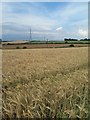
Billingley barley
From the footpath shown on the map as King's Stocks.
Image: © Steve Fareham
Taken: 20 Jul 2014
0.23 miles