IMAGES TAKEN NEAR TO
Low Folds, BARNSLEY, S71 5SB
Introduction
This page details the photographs taken nearby to Low Folds, S71 5SB by members of the Geograph project.
The Geograph project started in 2005 with the aim of publishing, organising and preserving representative images for every square kilometre of Great Britain, Ireland and the Isle of Man.

There are currently over 7.5m images from over14,400 individuals and you can help contribute to the project by visiting https://www.geograph.org.uk
Image Map
Images are licensed for reuse under creativecommons.org/licenses/by-sa/2.0
Notes
- Clicking on the map will re-center to the selected point.
- The higher the marker number, the further away the image location is from the centre of the postcode.
Image Listing (13 Images Found)
Images are licensed for reuse under creativecommons.org/licenses/by-sa/2.0
Image
Details
Distance
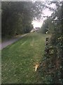
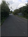
1

Pipeline by Trans Pennine Trail
The pipe may carry water, or sewage, or something else altogether!
Image: © Chris Morgan
Taken: 30 Nov 2012
0.05 miles

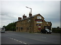
3
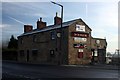
The Old Bridge Inn
On Burton Road opposite the Ardargh glass works.
Image: © Graham Hogg
Taken: 30 Nov 2012
0.13 miles


10
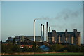
Glass Factory
There is a long tradition of glass making in Barnsley dating back to the 18th century. This site is one of the few remaining factories still in operation in the borough.
Image: © John Haig
Taken: 2 Oct 2004
0.21 miles