IMAGES TAKEN NEAR TO
Monk Terrace, BARNSLEY, S71 5RR
Introduction
This page details the photographs taken nearby to Monk Terrace, S71 5RR by members of the Geograph project.
The Geograph project started in 2005 with the aim of publishing, organising and preserving representative images for every square kilometre of Great Britain, Ireland and the Isle of Man.

There are currently over 7.5m images from over14,400 individuals and you can help contribute to the project by visiting https://www.geograph.org.uk
Image Map (Loading...)


Getting Data...Please wait
Leaflet Map data © OpenStreetMap
Images are licensed for reuse under creativecommons.org/licenses/by-sa/2.0
Notes
- Clicking on the map will re-center to the selected point.
- The higher the marker number, the further away the image location is from the centre of the postcode.
Image Listing (14 Images Found)
Images are licensed for reuse under creativecommons.org/licenses/by-sa/2.0
Image
Details
Distance
1

Bridge over the former railway
This bridge used to cross the Tapton Junction (Chesterfield) to Colne railway line. The line now operates as a freight only line to the industrial site just north of here with the line under this bridge long dismantled. National Cycle Network route 67 runs along here.
Image: © DS Pugh
Taken: 13 Apr 2025
0.06 miles
2

Monk Bretton railway station (site), Yorkshire
Believed to have opened in 1875 by the Midland Railway on the line from Cudworth to Barnsley Courthouse, this station closed to passengers in 1937.
View north east towards Cudworth. The two-platform station was located down in the cutting. Because of all the undergrowth, it was hard to see if any trace survives, at the time this image was taken.
Image: © Nigel Thompson
Taken: 23 Jan 2018
0.07 miles
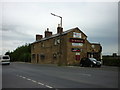
4
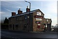
The Old Bridge Inn
On Burton Road opposite the Ardargh glass works.
Image: © Graham Hogg
Taken: 30 Nov 2012
0.12 miles

7

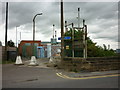
Pipeline by Trans Pennine Trail
The pipe may carry water, or sewage, or something else altogether!
Image: © Chris Morgan
Taken: 30 Nov 2012
0.16 miles
8

NCN67 leaving Burton Road
National Cycle Network route 67 immediately south of Burton Road.
Image: © DS Pugh
Taken: 13 Apr 2025
0.17 miles
9

Cycle path and pipeline
National Cycle Network route 67 heading towards Lundwood.
Image: © DS Pugh
Taken: 13 Apr 2025
0.20 miles
10

Redfearn's Glass works.
Now renamed after acquisition by an Irish company.
Image: © Steve Fareham
Taken: 14 Sep 2007
0.20 miles