IMAGES TAKEN NEAR TO
Brookfield, BARNSLEY, S71 5FH
Introduction
This page details the photographs taken nearby to Brookfield, S71 5FH by members of the Geograph project.
The Geograph project started in 2005 with the aim of publishing, organising and preserving representative images for every square kilometre of Great Britain, Ireland and the Isle of Man.

There are currently over 7.5m images from over14,400 individuals and you can help contribute to the project by visiting https://www.geograph.org.uk
Image Map
Images are licensed for reuse under creativecommons.org/licenses/by-sa/2.0
Notes
- Clicking on the map will re-center to the selected point.
- The higher the marker number, the further away the image location is from the centre of the postcode.
Image Listing (6 Images Found)
Images are licensed for reuse under creativecommons.org/licenses/by-sa/2.0
Image
Details
Distance
1
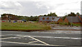
Baxter's
This has been a roadside café, jet petrol garage and is now being developed with luxury bungalows.
Image: © Steve Fareham
Taken: 13 Aug 2007
0.02 miles
2

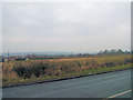
Footpath Near the Outskirts of Darfield
The north west fringes of Darfield can be seen through the gloom on the left of picture.
Image: © Jonathan Clitheroe
Taken: 31 Jan 2017
0.07 miles
3
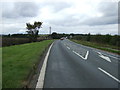
Doncaster Road (A635)
Heading north west towards Barnsley.
Image: © JThomas
Taken: 27 Sep 2014
0.15 miles
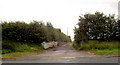
5
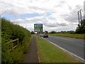
The yew tree junction into Darfield.
Named after the tree at the junction.
Image: © Steve Fareham
Taken: 13 Aug 2007
0.21 miles
6
Entrance off the A635 to Cranford Hall.
Image: © Steve Fareham
Taken: 13 Aug 2007
0.24 miles