IMAGES TAKEN NEAR TO
Heathland Court, BARNSLEY, S71 5FF
Introduction
This page details the photographs taken nearby to Heathland Court, S71 5FF by members of the Geograph project.
The Geograph project started in 2005 with the aim of publishing, organising and preserving representative images for every square kilometre of Great Britain, Ireland and the Isle of Man.

There are currently over 7.5m images from over14,400 individuals and you can help contribute to the project by visiting https://www.geograph.org.uk
Image Map
Images are licensed for reuse under creativecommons.org/licenses/by-sa/2.0
Notes
- Clicking on the map will re-center to the selected point.
- The higher the marker number, the further away the image location is from the centre of the postcode.
Image Listing (12 Images Found)
Images are licensed for reuse under creativecommons.org/licenses/by-sa/2.0
Image
Details
Distance
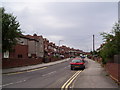
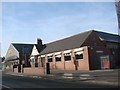
1
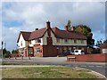
The Priory Arms, Rotherham Road, Barnsley
Image: © Geoff Pick
Taken: 3 Oct 2009
0.16 miles
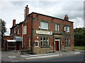
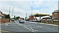
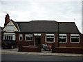
3
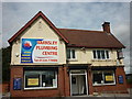
Barnsley Plumbing Centre
This building was the Priory Arms public house.
Image: © Ian S
Taken: 18 Aug 2012
0.17 miles
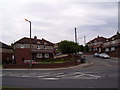
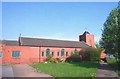
8
Inauspicious entry point to Dearne Valley Park
Image: © Chris Morgan
Taken: 2 Sep 2022
0.23 miles
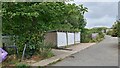
10
The Lundwood Social Club
A Sam Smith's club in Lundwood.
Image: © Ian S
Taken: 18 Aug 2012
0.24 miles