IMAGES TAKEN NEAR TO
Berkeley Croft, BARNSLEY, S71 4SJ
Introduction
This page details the photographs taken nearby to Berkeley Croft, S71 4SJ by members of the Geograph project.
The Geograph project started in 2005 with the aim of publishing, organising and preserving representative images for every square kilometre of Great Britain, Ireland and the Isle of Man.

There are currently over 7.5m images from over14,400 individuals and you can help contribute to the project by visiting https://www.geograph.org.uk
Image Map
Images are licensed for reuse under creativecommons.org/licenses/by-sa/2.0
Notes
- Clicking on the map will re-center to the selected point.
- The higher the marker number, the further away the image location is from the centre of the postcode.
Image Listing (85 Images Found)
Images are licensed for reuse under creativecommons.org/licenses/by-sa/2.0
Image
Details
Distance
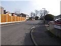
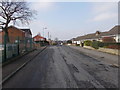
2
Buckingham Way - Manor Occupation Way
Image: © Betty Longbottom
Taken: 14 Feb 2017
0.04 miles
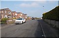
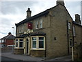
3

Boswell Close - Manor Occupation Road
Image: © Betty Longbottom
Taken: 14 Feb 2017
0.05 miles
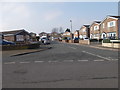
5
Manor Occupation Road - Oakwood Road
Image: © Betty Longbottom
Taken: 14 Feb 2017
0.08 miles
6
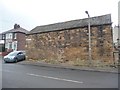
Old stone building on Summer Lane
Once entered from the lane, now just from the courtyard.
Image: © Christine Johnstone
Taken: 9 Feb 2011
0.08 miles

9
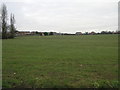
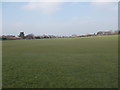
Playing Fields
This wide open space surrounded by houses is home to at least two football pitches and the inevitable dog walkers.
Image: © Michael Patterson
Taken: 9 Mar 2006
0.08 miles