IMAGES TAKEN NEAR TO
Vicarage Lane, BARNSLEY, S71 4QY
Introduction
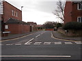
This page details the photographs taken nearby to Vicarage Lane, S71 4QY by members of the Geograph project.
The Geograph project started in 2005 with the aim of publishing, organising and preserving representative images for every square kilometre of Great Britain, Ireland and the Isle of Man.

There are currently over 7.5m images from over14,400 individuals and you can help contribute to the project by visiting https://www.geograph.org.uk
Image Map
Images are licensed for reuse under creativecommons.org/licenses/by-sa/2.0
Notes
- Clicking on the map will re-center to the selected point.
- The higher the marker number, the further away the image location is from the centre of the postcode.
Image Listing (75 Images Found)
Images are licensed for reuse under creativecommons.org/licenses/by-sa/2.0
Image
Details
Distance
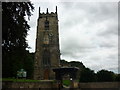
1
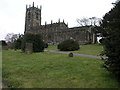
St John Baptist Church
St John Baptist Church, Royston, stands raised above the road level.
Image: © Michael Patterson
Taken: 9 Mar 2006
0.03 miles
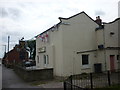
3
St John the Baptist Vicarage - Church Street
Image: © Betty Longbottom
Taken: 10 Jan 2017
0.05 miles
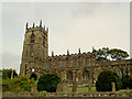
7
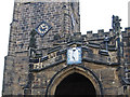
Royston - St John The Baptist Church - sundial and clock
Image: © Dave Bevis
Taken: 2 Dec 2013
0.07 miles
8
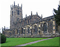
Royston - St John The Baptist Church - from SE
Image: © Dave Bevis
Taken: 2 Dec 2013
0.07 miles
10
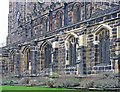
Royston - St John The Baptist Church - nave windows
Image: © Dave Bevis
Taken: 2 Dec 2013
0.07 miles