IMAGES TAKEN NEAR TO
Meadstead Drive, BARNSLEY, S71 4JS
Introduction
This page details the photographs taken nearby to Meadstead Drive, S71 4JS by members of the Geograph project.
The Geograph project started in 2005 with the aim of publishing, organising and preserving representative images for every square kilometre of Great Britain, Ireland and the Isle of Man.

There are currently over 7.5m images from over14,400 individuals and you can help contribute to the project by visiting https://www.geograph.org.uk
Image Map
Images are licensed for reuse under creativecommons.org/licenses/by-sa/2.0
Notes
- Clicking on the map will re-center to the selected point.
- The higher the marker number, the further away the image location is from the centre of the postcode.
Image Listing (71 Images Found)
Images are licensed for reuse under creativecommons.org/licenses/by-sa/2.0
Image
Details
Distance
9
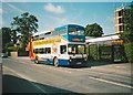
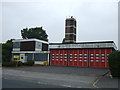
Bus on High Street, Royston
Stagecoach Yorkshire 16871, a Volvo Olympian/Northern Counties Palatine new to London Central, stands outside the old fire station while working route 57 to Barnsley. The fire station has since been demolished and replaced with housing.
Image: © Richard Vince
Taken: 8 Sep 2007
0.06 miles