IMAGES TAKEN NEAR TO
The Green, BARNSLEY, S71 4JN
Introduction
This page details the photographs taken nearby to The Green, S71 4JN by members of the Geograph project.
The Geograph project started in 2005 with the aim of publishing, organising and preserving representative images for every square kilometre of Great Britain, Ireland and the Isle of Man.

There are currently over 7.5m images from over14,400 individuals and you can help contribute to the project by visiting https://www.geograph.org.uk
Image Map
Images are licensed for reuse under creativecommons.org/licenses/by-sa/2.0
Notes
- Clicking on the map will re-center to the selected point.
- The higher the marker number, the further away the image location is from the centre of the postcode.
Image Listing (79 Images Found)
Images are licensed for reuse under creativecommons.org/licenses/by-sa/2.0
Image
Details
Distance
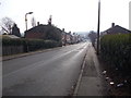
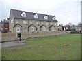
1
Bungalows on The Green
Taken from the south-west corner of the open space, at Redwood Avenue.
Image: © Christine Johnstone
Taken: 9 Feb 2011
0.03 miles
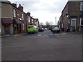
2
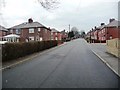
Redwood Avenue, Royston
Climbing up the hill to the appropriately named High Street.
Image: © Christine Johnstone
Taken: 9 Feb 2011
0.06 miles
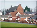
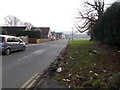
3
Redwood Mews, off Redwood Avenue
Developed in the corner of one of Royston's green spaces, with the footpath diverted round.
Image: © Christine Johnstone
Taken: 9 Feb 2011
0.06 miles
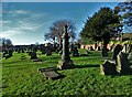
4
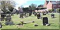
Royston Cemetery - viewed from off Church Street
Image: © Betty Longbottom
Taken: 31 Mar 2017
0.06 miles
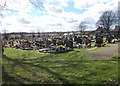
7
Royston Cemetery - viewed from off Church Street
Image: © Betty Longbottom
Taken: 31 Mar 2017
0.07 miles