IMAGES TAKEN NEAR TO
Lund Hill Lane, BARNSLEY, S71 4BB
Introduction
This page details the photographs taken nearby to Lund Hill Lane, S71 4BB by members of the Geograph project.
The Geograph project started in 2005 with the aim of publishing, organising and preserving representative images for every square kilometre of Great Britain, Ireland and the Isle of Man.

There are currently over 7.5m images from over14,400 individuals and you can help contribute to the project by visiting https://www.geograph.org.uk
Image Map
Images are licensed for reuse under creativecommons.org/licenses/by-sa/2.0
Notes
- Clicking on the map will re-center to the selected point.
- The higher the marker number, the further away the image location is from the centre of the postcode.
Image Listing (59 Images Found)
Images are licensed for reuse under creativecommons.org/licenses/by-sa/2.0
Image
Details
Distance
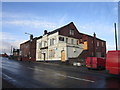
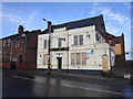
1
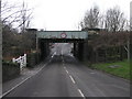
Rusty Bridge
This bridge carries the railway over Lund Hill Lane.
Image: © Michael Patterson
Taken: 9 Mar 2006
0.02 miles
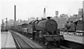
2
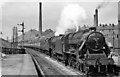
Royston & Notton Station, with train
View northward, towards Normanton and Leeds etc. The Up Thames-Clyde Express (09.20 Glasgow St Enoch to London St Pancras) makes a fine sight, double-headed by Stanier Class 5 (modified with double-chimney and Caprotti valve-gear) No. 44756 piloting 'Jubilee' Class 6 4-6-0 No. 45615 'Malay States'. Behind are the chimneys associated with New Monckton Colliery. In those days (1951), this was the four-track trunk route of the ex-Midland Railway main line between Sheffield and Leeds, through a region that teemed with heavy industry, coal mines, railway yards and junctions, with an immense amount of freight traffic. However, mining subsidence forced express trains to slow down through here. From 1/1/68 all passenger services ceased, Royston & Notton station closed and since 9/68 nothing has passed this way and the traffic that is left runs on other lines - if not by the M1! As we all know, since the 1980s the mines have been closed and industry along with rail freight traffic is a shadow of what it was.
Image: © Ben Brooksbank
Taken: 24 Jul 1951
0.02 miles


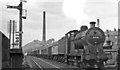
5
Up fast freight train passing Royston & Notton station
View northward, towards Normanton and Leeds; ex-Midland main line Sheffield - Leeds, part of the Midland trunk route London - Sheffield - Leeds - Carlisle, but a section demoted/closed in the 1960s owing to mining subsidence. In 1951 the section was still very busy: the Up Class D freight (headed by Hughes/Fowler 5P4F 2-6-0 No. 42794) is on the Fast lines, while across the platform on the Slows lines a Down freight passes with LMS 4F 0-6-0 No. 44374. Behind is New Monckton Colliery.
Image: © Ben Brooksbank
Taken: 24 Jul 1951
0.04 miles
7
Up freight at Royston & Notton
View northward from the station, towards Normanton and Leeds: ex-Midland Sheffield - Leeds main line, disused since 1968 owing to mining subsidences: the 'C' board marks the commencement of a temporary speed restriction, no doubt due to one of these. (See Image]). The Class H freight is headed by LMS Fowler 4F 0-6-0 No. 44538 (built 1928, withdrawn 1/64). Behind is New Moncton Colliery.
Image: © Ben Brooksbank
Taken: 24 Jul 1951
0.06 miles