IMAGES TAKEN NEAR TO
Cross Lane, BARNSLEY, S71 4AR
Introduction
This page details the photographs taken nearby to Cross Lane, S71 4AR by members of the Geograph project.
The Geograph project started in 2005 with the aim of publishing, organising and preserving representative images for every square kilometre of Great Britain, Ireland and the Isle of Man.

There are currently over 7.5m images from over14,400 individuals and you can help contribute to the project by visiting https://www.geograph.org.uk
Image Map
Images are licensed for reuse under creativecommons.org/licenses/by-sa/2.0
Notes
- Clicking on the map will re-center to the selected point.
- The higher the marker number, the further away the image location is from the centre of the postcode.
Image Listing (40 Images Found)
Images are licensed for reuse under creativecommons.org/licenses/by-sa/2.0
Image
Details
Distance
1
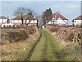
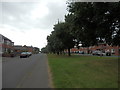
Houses on the north side of Church Hill
Seen from the bridleway from Carlton.
Image: © Christine Johnstone
Taken: 9 Feb 2011
0.08 miles
2
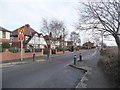
Mind the bollards
Traffic management on Church Hill, Royston.
Image: © Christine Johnstone
Taken: 9 Feb 2011
0.09 miles
3
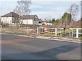
Entrance to the Barnsley Canal towpath
The signs warns of dangerous thin ice, even though the canal is extremely shallow here.
Image: © Christine Johnstone
Taken: 9 Feb 2011
0.10 miles
4
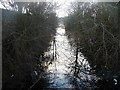
The Barnsley Canal, south of Royston Bridge
Tangled in trees, but fairly weed-free.
Image: © Christine Johnstone
Taken: 9 Feb 2011
0.12 miles
5
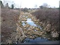
The Barnsley Canal, north of Royston Bridge
Shallow and weedy, but a clear route down to Wakefield.
Image: © Christine Johnstone
Taken: 9 Feb 2011
0.12 miles
6
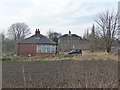
Bungalow on the south side of Church Hill
With the stone-built canalside building behind.
Image: © Christine Johnstone
Taken: 9 Feb 2011
0.13 miles
7
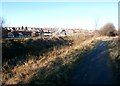
Trans Pennine Trail and Barnsley Canal at Royston
The Barnsley Canal was opened in 1798 in order to transport coal from the Barnsley coal fields to the River Calder and beyond. It last saw traffic in 1950 and closed three years later.
Image: © Jonathan Clitheroe
Taken: 14 Jan 2017
0.13 miles
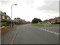
10
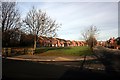
Meadow Road, Royston
Viewed from its junction with Cross Hill
Image: © Graham Hogg
Taken: 30 Nov 2012
0.14 miles