IMAGES TAKEN NEAR TO
Totley Close, BARNSLEY, S71 3RL
Introduction
This page details the photographs taken nearby to Totley Close, S71 3RL by members of the Geograph project.
The Geograph project started in 2005 with the aim of publishing, organising and preserving representative images for every square kilometre of Great Britain, Ireland and the Isle of Man.

There are currently over 7.5m images from over14,400 individuals and you can help contribute to the project by visiting https://www.geograph.org.uk
Image Map
Images are licensed for reuse under creativecommons.org/licenses/by-sa/2.0
Notes
- Clicking on the map will re-center to the selected point.
- The higher the marker number, the further away the image location is from the centre of the postcode.
Image Listing (13 Images Found)
Images are licensed for reuse under creativecommons.org/licenses/by-sa/2.0
Image
Details
Distance
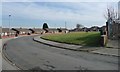
2
The eastern end of Derwent Crescent, Athersley South
Athersley South is a suburb on the north side of Barnsley, South Yorkshire. With street names like Bamford, Bakewell, Buxton, Crich, Cromford, Chatsworth, Derwent, Hardwick, Lea and Matlock, someone was fond of Derbyshire.
Image: © Christine Johnstone
Taken: 9 Mar 2018
0.10 miles
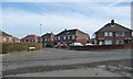
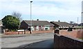
3
Carlton Road, looking towards Laithes Lane, Athersley South.
Image: © Bill Henderson
Taken: 4 Feb 2007
0.10 miles
4
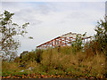
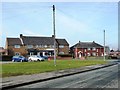
Regeneration
Another new office in the course of construction.
Image: © Steve Fareham
Taken: 27 Oct 2007
0.13 miles
5
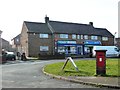
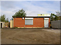
Postbox, chippy and convenience store, Derwent Road
This is Athersley South, a suburb on the north side of Barnsley, South Yorkshire. With street names like Bamford, Bakewell, Buxton, Crich, Cromford, Chatsworth, Derwent, Hardwick, Lea and Matlock, someone was fond of Derbyshire.
Image: © Christine Johnstone
Taken: 9 Mar 2018
0.15 miles
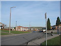
6
Shops on Derwent Road, Athersley South
Athersley South is a suburb on the north side of Barnsley, South Yorkshire. With street names like Bamford, Bakewell, Buxton, Crich, Cromford, Chatsworth, Derwent, Hardwick, Lea and Matlock, someone was fond of Derbyshire.
Image: © Christine Johnstone
Taken: 9 Mar 2018
0.16 miles
7
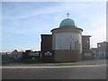
St Michael's Catholic and Church of England High School.
Image: © Bill Henderson
Taken: 4 Feb 2007
0.18 miles
8
West side of Peveril Crescent, Athersley South
Athersley South is a suburb on the north side of Barnsley, South Yorkshire. With street names like Bamford, Bakewell, Buxton, Crich, Cromford, Chatsworth, Derwent, Hardwick, Lea, Matlock and Peveril, someone was fond of Derbyshire.
Image: © Christine Johnstone
Taken: 9 Mar 2018
0.18 miles
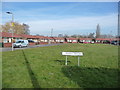
9
Cutting the corner across the grass, Cromford Avenue
This is Athersley South, a suburb on the north side of Barnsley, South Yorkshire. With street names like Bamford, Bakewell, Buxton, Crich, Cromford, Chatsworth, Hardwick, Lea and Matlock, someone was fond of Derbyshire.
Image: © Christine Johnstone
Taken: 9 Mar 2018
0.19 miles
10
North side of Lea Road, Athersley South
Athersley South is a suburb on the north side of Barnsley, South Yorkshire. With street names like Bamford, Bakewell, Buxton, Crich, Cromford, Chatsworth, Hardwick, Lea and Matlock, someone was fond of Derbyshire.
Image: © Christine Johnstone
Taken: 9 Mar 2018
0.21 miles