IMAGES TAKEN NEAR TO
Wakefield Road, BARNSLEY, S71 3LS
Introduction
This page details the photographs taken nearby to Wakefield Road, S71 3LS by members of the Geograph project.
The Geograph project started in 2005 with the aim of publishing, organising and preserving representative images for every square kilometre of Great Britain, Ireland and the Isle of Man.

There are currently over 7.5m images from over14,400 individuals and you can help contribute to the project by visiting https://www.geograph.org.uk
Image Map
Images are licensed for reuse under creativecommons.org/licenses/by-sa/2.0
Notes
- Clicking on the map will re-center to the selected point.
- The higher the marker number, the further away the image location is from the centre of the postcode.
Image Listing (7 Images Found)
Images are licensed for reuse under creativecommons.org/licenses/by-sa/2.0
Image
Details
Distance

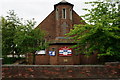
3
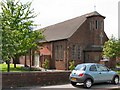
St.Helen's Church
Church of England on the B6132 at Athersley (south).
Image: © Roger May
Taken: 25 May 2006
0.17 miles
5

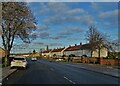
Out with the old and in with the new
New Lodge Crescent, New Lodge Estate some of the houses have been demolished for rebuilds. The old post war concrete sectioned road is clearly visible. I wonder if this will be dug up and rebuildsor just resurfaced?
Image: © John Fielding
Taken: 29 Oct 2009
0.20 miles
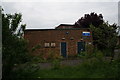
7
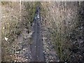
Footpath to Royston from old Staincross Station Bridge
The bridge is at the junction of the A61 Barnsley Wakefield Road and the B6131 to Darton.
Image: © John Fielding
Taken: 25 Feb 2008
0.25 miles