IMAGES TAKEN NEAR TO
Longfields Road, BARNSLEY, S71 3HT
Introduction
This page details the photographs taken nearby to Longfields Road, S71 3HT by members of the Geograph project.
The Geograph project started in 2005 with the aim of publishing, organising and preserving representative images for every square kilometre of Great Britain, Ireland and the Isle of Man.

There are currently over 7.5m images from over14,400 individuals and you can help contribute to the project by visiting https://www.geograph.org.uk
Image Map
Images are licensed for reuse under creativecommons.org/licenses/by-sa/2.0
Notes
- Clicking on the map will re-center to the selected point.
- The higher the marker number, the further away the image location is from the centre of the postcode.
Image Listing (5 Images Found)
Images are licensed for reuse under creativecommons.org/licenses/by-sa/2.0
Image
Details
Distance
1
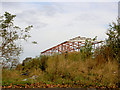
Regeneration
Another new office in the course of construction.
Image: © Steve Fareham
Taken: 27 Oct 2007
0.07 miles
3

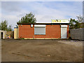
Ordnance Survey Flush Bracket S9467
This can be found on a building (now a garage) that was once part of the offices at the former Wharncliffe Woodmoor Colliery.
For more detail see : http://www.bench-marks.org.uk/bm21589
Image: © Peter Wood
Taken: 17 Jun 2014
0.18 miles
4
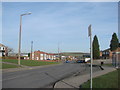
Carlton Road, looking towards Laithes Lane, Athersley South.
Image: © Bill Henderson
Taken: 4 Feb 2007
0.21 miles
5
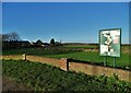
Wharncliffe Woodmoor Recreation Grounds
Standing on this spot in 1888 one would have seen the sprawling sight of Wharncliffe Woodmoor Colliery.
Image: © Neil Theasby
Taken: 4 Jan 2022
0.24 miles