IMAGES TAKEN NEAR TO
Far Lawns, BARNSLEY, S71 3FL
Introduction
This page details the photographs taken nearby to Far Lawns, S71 3FL by members of the Geograph project.
The Geograph project started in 2005 with the aim of publishing, organising and preserving representative images for every square kilometre of Great Britain, Ireland and the Isle of Man.

There are currently over 7.5m images from over14,400 individuals and you can help contribute to the project by visiting https://www.geograph.org.uk
Image Map
Images are licensed for reuse under creativecommons.org/licenses/by-sa/2.0
Notes
- Clicking on the map will re-center to the selected point.
- The higher the marker number, the further away the image location is from the centre of the postcode.
Image Listing (44 Images Found)
Images are licensed for reuse under creativecommons.org/licenses/by-sa/2.0
Image
Details
Distance
1
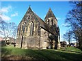
Church of St John the Evangelist in Carlton
Image: © Jonathan Clitheroe
Taken: 14 Jan 2017
0.01 miles
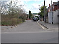
4
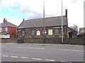
Carlton Parish Hall - Church Street
Image: © Betty Longbottom
Taken: 31 Mar 2017
0.04 miles
5
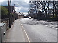
Church Street - viewed from Carlton Road
Image: © Betty Longbottom
Taken: 31 Mar 2017
0.04 miles
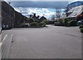
6
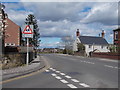
Royston Lane - viewed from Carlton Road
Image: © Betty Longbottom
Taken: 31 Mar 2017
0.05 miles
7

Carlton War Memorial
In front of St John the Evangelist Church.
Image: © JThomas
Taken: 25 Sep 2013
0.05 miles
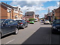
8
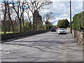
Carlton Road - viewed from Royston Lane
Image: © Betty Longbottom
Taken: 31 Mar 2017
0.06 miles
9
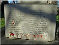
The Glorious Dead
Names and crosses on the war memorial at Carlton, Barnsley
Image: © Neil Theasby
Taken: 4 Jan 2022
0.06 miles