IMAGES TAKEN NEAR TO
Folly Croft, BARNSLEY, S71 2SS
Introduction
This page details the photographs taken nearby to Folly Croft, S71 2SS by members of the Geograph project.
The Geograph project started in 2005 with the aim of publishing, organising and preserving representative images for every square kilometre of Great Britain, Ireland and the Isle of Man.

There are currently over 7.5m images from over14,400 individuals and you can help contribute to the project by visiting https://www.geograph.org.uk
Image Map
Images are licensed for reuse under creativecommons.org/licenses/by-sa/2.0
Notes
- Clicking on the map will re-center to the selected point.
- The higher the marker number, the further away the image location is from the centre of the postcode.
Image Listing (16 Images Found)
Images are licensed for reuse under creativecommons.org/licenses/by-sa/2.0
Image
Details
Distance
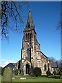
1
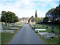
Monk Bretton Cemetery
The spire of St Paul's Church can be seen
Image: © Geoff Pick
Taken: 3 Oct 2009
0.09 miles
5
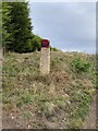
Odd painted marker on the way to Monk Bretton Trig Point
Image: © thejackrustles
Taken: 12 Oct 2021
0.14 miles
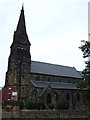
7

St Paul's Church, Monk Bretton
The church dates from 1878 and is a grade II listed building.
Image: © Graham Hogg
Taken: 11 Jan 2012
0.14 miles
8
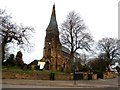
Church of St Paul in Monk Bretton
Viewed from Cross Street.
Image: © Jonathan Clitheroe
Taken: 3 Feb 2017
0.14 miles
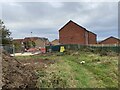
9
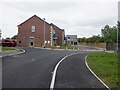
Folly Way
Newly built houses in Monk Bretton.
Image: © Richard Webb
Taken: 30 May 2023
0.15 miles