IMAGES TAKEN NEAR TO
Lamb Lane, BARNSLEY, S71 2PU
Introduction
This page details the photographs taken nearby to Lamb Lane, S71 2PU by members of the Geograph project.
The Geograph project started in 2005 with the aim of publishing, organising and preserving representative images for every square kilometre of Great Britain, Ireland and the Isle of Man.

There are currently over 7.5m images from over14,400 individuals and you can help contribute to the project by visiting https://www.geograph.org.uk
Image Map (Loading...)


Getting Data...Please wait
Leaflet Map data © OpenStreetMap
Images are licensed for reuse under creativecommons.org/licenses/by-sa/2.0
Notes
- Clicking on the map will re-center to the selected point.
- The higher the marker number, the further away the image location is from the centre of the postcode.
Image Listing (8 Images Found)
Images are licensed for reuse under creativecommons.org/licenses/by-sa/2.0
Image
Details
Distance
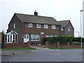
2
Fed-up with Fedex!
Congestion as yet another parked delivery van chokes the traffic on a busy corner.
Image: © Chris Morgan
Taken: 30 Nov 2012
0.21 miles
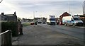
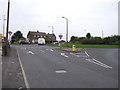
3
Burton Road Roundabout, from Fish Dam Lane.
Image: © Bill Henderson
Taken: 4 Feb 2007
0.22 miles
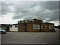
4
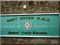
The West Green WMC
A Sam Smith's club in Monk Bretton.
Image: © Ian S
Taken: 18 Aug 2012
0.22 miles
5
The West Green WMC
A Sam Smith's club in Monk Bretton.
Image: © Ian S
Taken: 18 Aug 2012
0.23 miles
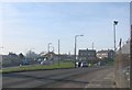
6
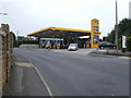
Service station, Monk Bretton
On Burton Road.
Image: © JThomas
Taken: 25 Sep 2013
0.23 miles
8
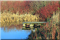
Monk Bretton Park Pond
The pond lies in the north east corner of the park.
Image: © Martin Lee
Taken: 13 Jan 2012
0.24 miles