IMAGES TAKEN NEAR TO
Sheridan Court, BARNSLEY, S71 2LT
Introduction
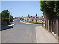
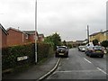
This page details the photographs taken nearby to Sheridan Court, S71 2LT by members of the Geograph project.
The Geograph project started in 2005 with the aim of publishing, organising and preserving representative images for every square kilometre of Great Britain, Ireland and the Isle of Man.

There are currently over 7.5m images from over14,400 individuals and you can help contribute to the project by visiting https://www.geograph.org.uk
Image Map
Images are licensed for reuse under creativecommons.org/licenses/by-sa/2.0
Notes
- Clicking on the map will re-center to the selected point.
- The higher the marker number, the further away the image location is from the centre of the postcode.
Image Listing (4 Images Found)
Images are licensed for reuse under creativecommons.org/licenses/by-sa/2.0
Image
Details
Distance
2
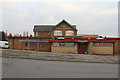
Full House Public House
Situated on the corner of Warwick Road and Rotherham Road is this Public House. The housing estate in close proximity is often referred to as the Full House Estate although most of the names are of writers.
Image: © Martin Lee
Taken: 31 Jan 2012
0.14 miles