IMAGES TAKEN NEAR TO
Cliffe Lane, BARNSLEY, S71 2LJ
Introduction
This page details the photographs taken nearby to Cliffe Lane, S71 2LJ by members of the Geograph project.
The Geograph project started in 2005 with the aim of publishing, organising and preserving representative images for every square kilometre of Great Britain, Ireland and the Isle of Man.

There are currently over 7.5m images from over14,400 individuals and you can help contribute to the project by visiting https://www.geograph.org.uk
Image Map
Images are licensed for reuse under creativecommons.org/licenses/by-sa/2.0
Notes
- Clicking on the map will re-center to the selected point.
- The higher the marker number, the further away the image location is from the centre of the postcode.
Image Listing (11 Images Found)
Images are licensed for reuse under creativecommons.org/licenses/by-sa/2.0
Image
Details
Distance
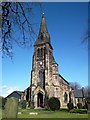
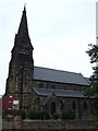
2
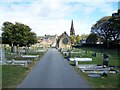
Monk Bretton Cemetery
The spire of St Paul's Church can be seen
Image: © Geoff Pick
Taken: 3 Oct 2009
0.18 miles


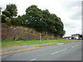
7

Filled in canal
What is now a small playing field was the route of the old canal that has been filled in.
Image: © Martin Lee
Taken: 29 Jan 2012
0.23 miles
8
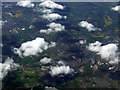
Barnsley from the air
Monk Bretton is in the foreground, Oakwell Stadium (Barnsley FC) can be seen to the lower right.
Image: © Thomas Nugent
Taken: 18 Apr 2014
0.24 miles