IMAGES TAKEN NEAR TO
Aqueduct Street, BARNSLEY, S71 1QQ
Introduction
This page details the photographs taken nearby to Aqueduct Street, S71 1QQ by members of the Geograph project.
The Geograph project started in 2005 with the aim of publishing, organising and preserving representative images for every square kilometre of Great Britain, Ireland and the Isle of Man.

There are currently over 7.5m images from over14,400 individuals and you can help contribute to the project by visiting https://www.geograph.org.uk
Image Map
Images are licensed for reuse under creativecommons.org/licenses/by-sa/2.0
Notes
- Clicking on the map will re-center to the selected point.
- The higher the marker number, the further away the image location is from the centre of the postcode.
Image Listing (28 Images Found)
Images are licensed for reuse under creativecommons.org/licenses/by-sa/2.0
Image
Details
Distance
1
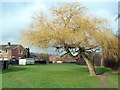
Winter tree in Honeywell
The open area is on the line of the former Barnsley Canal (Barnby Basin branch). The canal closed in 1953 at which time the tree might have been a sapling on the towpath.
Image: © Graham Hogg
Taken: 11 Jan 2012
0.10 miles
2
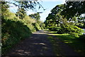
Penistone Rail Trail towards Smithies Lane, Barnsley
Image: © Ian S
Taken: 24 Aug 2016
0.10 miles
3
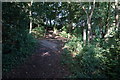
Penistone Rail Trail near the Fleets, Barnsley
Image: © Ian S
Taken: 24 Aug 2016
0.11 miles

5
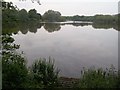
The Fleets
Angler's Lake next to the River Dearne.
Image: © Jonathan Clitheroe
Taken: 13 Jun 2015
0.14 miles
6
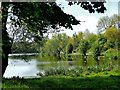
The Fleets
A large fishing lake close to Barnsley Town Centre in South Yorkshire England.
https://www.flickr.com/photos/tomcurtisvideos/
Image: © Tom Curtis
Taken: 17 May 2016
0.14 miles
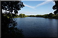
8
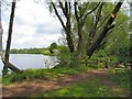
The Fleets
Another view of this popular angler's lake, looking north up the east bank from the shade of the trees.
Image: © Roger May
Taken: 25 May 2006
0.15 miles
9
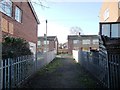
Footpath to Hartington Drive, Honeywell
Heading west from open space that was once the route of the Barnsley Canal.
Image: © Christine Johnstone
Taken: 31 Dec 2017
0.16 miles