IMAGES TAKEN NEAR TO
Brunswick Close, BARNSLEY, S71 1NQ
Introduction
This page details the photographs taken nearby to Brunswick Close, S71 1NQ by members of the Geograph project.
The Geograph project started in 2005 with the aim of publishing, organising and preserving representative images for every square kilometre of Great Britain, Ireland and the Isle of Man.

There are currently over 7.5m images from over14,400 individuals and you can help contribute to the project by visiting https://www.geograph.org.uk
Image Map
Images are licensed for reuse under creativecommons.org/licenses/by-sa/2.0
Notes
- Clicking on the map will re-center to the selected point.
- The higher the marker number, the further away the image location is from the centre of the postcode.
Image Listing (8 Images Found)
Images are licensed for reuse under creativecommons.org/licenses/by-sa/2.0
Image
Details
Distance
1
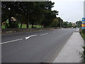
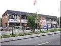
Wakefield Road (A61)
Heading south towards Barnsley.
Image: © JThomas
Taken: 25 Sep 2013
0.10 miles
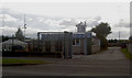
2
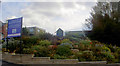
TA Centre
TA centre and new housing estate off Wakefield Road.
Image: © Steve Fareham
Taken: 30 Sep 2007
0.11 miles
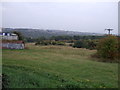
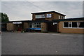
4
Bus garage
This was the site of Barnsley & Dis Bus garage it was taken in 2005 before it was taken over by Stagecoach and closed at the end of July 2006 and moved to Sheffield road in Barnsley.
Image: © John Douglas
Taken: Unknown
0.15 miles
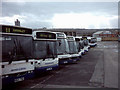
6
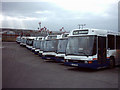
The Rest
The two photos http://www.geograph.org.uk/photo/274049 that makes most of the buses that were being used at this time.
Image: © John Douglas
Taken: Unknown
0.19 miles
8
New Lodge WMC on Wakefield Road, Barnsley
A free house selling some Sam Smith's products.
Image: © Ian S
Taken: 31 May 2014
0.24 miles