IMAGES TAKEN NEAR TO
Quarry Street, BARNSLEY, S71 1NA
Introduction
This page details the photographs taken nearby to Quarry Street, S71 1NA by members of the Geograph project.
The Geograph project started in 2005 with the aim of publishing, organising and preserving representative images for every square kilometre of Great Britain, Ireland and the Isle of Man.

There are currently over 7.5m images from over14,400 individuals and you can help contribute to the project by visiting https://www.geograph.org.uk
Image Map
Images are licensed for reuse under creativecommons.org/licenses/by-sa/2.0
Notes
- Clicking on the map will re-center to the selected point.
- The higher the marker number, the further away the image location is from the centre of the postcode.
Image Listing (13 Images Found)
Images are licensed for reuse under creativecommons.org/licenses/by-sa/2.0
Image
Details
Distance
1
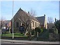
Smithies Wesleyan Reform Church, Wakefield Road, Smithies
Image: © Bill Henderson
Taken: 4 Feb 2007
0.07 miles
2
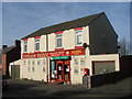
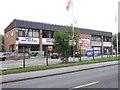
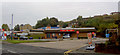
Bargain Booze and Post Office Shop, Smithies
Image: © Bill Henderson
Taken: 4 Feb 2007
0.09 miles
3
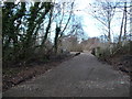
Railway bridge over Smithies Lane
This former railway line is now a public footpath. Barnsley had many railway lines, serving the many local collieries.
Image: © Christine Johnstone
Taken: 31 Dec 2017
0.12 miles
4
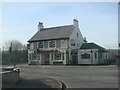
The Sportsman Public House, Walefield Road, Smithies
Image: © Bill Henderson
Taken: 4 Feb 2007
0.12 miles
5
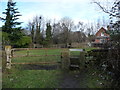
Public footpath on the former route of Smithies Lane
The road was diverted to bend under a new railway line.
Image: © Christine Johnstone
Taken: 31 Dec 2017
0.13 miles
7
Finger licking good
On Wakefield Road Barnsley.
Image: © Steve Fareham
Taken: 13 Oct 2007
0.21 miles