IMAGES TAKEN NEAR TO
Peel Place, BARNSLEY, S71 1LU
Introduction
This page details the photographs taken nearby to Peel Place, S71 1LU by members of the Geograph project.
The Geograph project started in 2005 with the aim of publishing, organising and preserving representative images for every square kilometre of Great Britain, Ireland and the Isle of Man.

There are currently over 7.5m images from over14,400 individuals and you can help contribute to the project by visiting https://www.geograph.org.uk
Image Map
Images are licensed for reuse under creativecommons.org/licenses/by-sa/2.0
Notes
- Clicking on the map will re-center to the selected point.
- The higher the marker number, the further away the image location is from the centre of the postcode.
Image Listing (27 Images Found)
Images are licensed for reuse under creativecommons.org/licenses/by-sa/2.0
Image
Details
Distance
2
The River Dearne
Pic taken from the bridge on the A61 at the side of ASDA.
Image: © John Fielding
Taken: 3 Feb 2009
0.10 miles
3
Buddies Children's Centre
Buddies Children’s Centre is a day nursery for children up to 5 years old and is based at the Burton Road Primary School.
Image: © Graham Hogg
Taken: 11 Jan 2012
0.11 miles
4
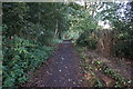
Penistone Rail Trail near the Fleets, Barnsley
Image: © Ian S
Taken: 24 Aug 2016
0.12 miles
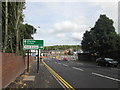
5
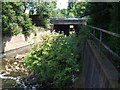
Footpath under new road
The new road to bypass the bottle neck will be open March 2012. The bridge looks like it will allow the footpath to carry on under the new road.
Image: © Martin Lee
Taken: 29 Jan 2012
0.13 miles
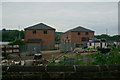
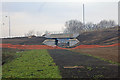
6
Big changes underway at the Wakefield Road/Burton Road junction
Image: © John Slater
Taken: 7 Oct 2013
0.14 miles
7
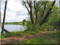
The Fleets
Another view of this popular angler's lake, looking north up the east bank from the shade of the trees.
Image: © Roger May
Taken: 25 May 2006
0.14 miles
8
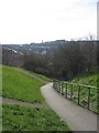
Burton Bank
View of and from the footpath that joins the upper part of Burton Bank Road, Monk Bretton, to the lower part. The town in the distance is Barnsley, and the tower on the skyline is that of Barnsley Town Hall.
Image: © Arthur Fisher
Taken: 23 Mar 2020
0.14 miles
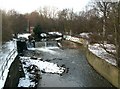
9
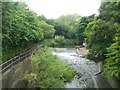
Weir on the River Dearne
Pictured from the road bridge on Old Mill Lane.
Image: © Jonathan Clitheroe
Taken: 13 Jun 2015
0.15 miles