IMAGES TAKEN NEAR TO
Honeywell Lane, BARNSLEY, S71 1JH
Introduction
This page details the photographs taken nearby to Honeywell Lane, S71 1JH by members of the Geograph project.
The Geograph project started in 2005 with the aim of publishing, organising and preserving representative images for every square kilometre of Great Britain, Ireland and the Isle of Man.

There are currently over 7.5m images from over14,400 individuals and you can help contribute to the project by visiting https://www.geograph.org.uk
Image Map (Loading...)


Getting Data...Please wait
Leaflet Map data © OpenStreetMap
Images are licensed for reuse under creativecommons.org/licenses/by-sa/2.0
Notes
- Clicking on the map will re-center to the selected point.
- The higher the marker number, the further away the image location is from the centre of the postcode.
Image Listing (15 Images Found)
Images are licensed for reuse under creativecommons.org/licenses/by-sa/2.0
Image
Details
Distance

3

Barnsley College
The chemical silo is an unusual feature for a college, but maybe they have a chemistry lab that needs it.
Image: © Stephen Craven
Taken: 5 Nov 2016
0.20 miles
4
Penistone Rail Trail near the Fleets, Barnsley
Image: © Ian S
Taken: 24 Aug 2016
0.20 miles

7
Penistone Rail Trail towards Smithies Lane, Barnsley
Image: © Ian S
Taken: 24 Aug 2016
0.23 miles
9
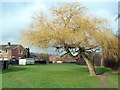
Winter tree in Honeywell
The open area is on the line of the former Barnsley Canal (Barnby Basin branch). The canal closed in 1953 at which time the tree might have been a sapling on the towpath.
Image: © Graham Hogg
Taken: 11 Jan 2012
0.23 miles