IMAGES TAKEN NEAR TO
Beech Street, BARNSLEY, S70 4HT
Introduction
This page details the photographs taken nearby to Beech Street, S70 4HT by members of the Geograph project.
The Geograph project started in 2005 with the aim of publishing, organising and preserving representative images for every square kilometre of Great Britain, Ireland and the Isle of Man.

There are currently over 7.5m images from over14,400 individuals and you can help contribute to the project by visiting https://www.geograph.org.uk
Image Map
Images are licensed for reuse under creativecommons.org/licenses/by-sa/2.0
Notes
- Clicking on the map will re-center to the selected point.
- The higher the marker number, the further away the image location is from the centre of the postcode.
Image Listing (33 Images Found)
Images are licensed for reuse under creativecommons.org/licenses/by-sa/2.0
Image
Details
Distance
4
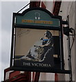
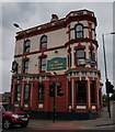
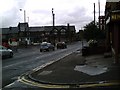
The Victoria Hotel
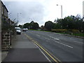
On Sheffield Road (A61).
Image: © JThomas
Taken: 27 Sep 2014
0.06 miles
5
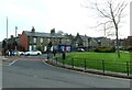
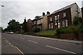
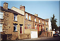
Houses on the junction of Sheffield Road and Park Road
Image: © Steve Daniels
Taken: 22 Apr 2023
0.06 miles
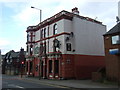
9
The Coach & Horses Sheffield Rd junc. Park Rd & Cemetery Rd
Image: © Peter Beard
Taken: 3 Jul 2007
0.10 miles
10
Numbers 22 to 34 Cope Street
Note numbers 26 and 28 still have the old stairs leading up to the front doors. The block 24 to 30 dates from around 1870 and curve away from the road, meaning that the fronts are wider than the backs.
Image: © Linda Hutton
Taken: Unknown
0.10 miles