IMAGES TAKEN NEAR TO
Heathfields, BARNSLEY, S70 3RT
Introduction
This page details the photographs taken nearby to Heathfields, S70 3RT by members of the Geograph project.
The Geograph project started in 2005 with the aim of publishing, organising and preserving representative images for every square kilometre of Great Britain, Ireland and the Isle of Man.

There are currently over 7.5m images from over14,400 individuals and you can help contribute to the project by visiting https://www.geograph.org.uk
Image Map
Images are licensed for reuse under creativecommons.org/licenses/by-sa/2.0
Notes
- Clicking on the map will re-center to the selected point.
- The higher the marker number, the further away the image location is from the centre of the postcode.
Image Listing (6 Images Found)
Images are licensed for reuse under creativecommons.org/licenses/by-sa/2.0
Image
Details
Distance
1
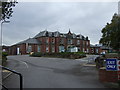
Kendray Hospital, Barnsley
Off Doncaster Road.
Image: © JThomas
Taken: 27 Sep 2014
0.16 miles
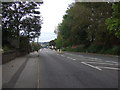
2
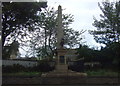
War Memorial on Doncaster Road
Opposite Kendray Hospital, Barnsley.
Image: © JThomas
Taken: 27 Sep 2014
0.16 miles
3
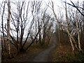
Birch Woodland and Trans Pennine Trail
A scenic stretch of the trail which is surprisingly close to the town centre. The Wombwell to Barnsley section of the Penistone Railway Line passes to the left of the railings.
Image: © Jonathan Clitheroe
Taken: 31 Jan 2017
0.18 miles
5
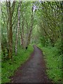
The Trans Pennine Trail (TPT) link enters Barnsley
This woodland trail is less than a mile from the centre of Barnsley.
Image: © Steve Fareham
Taken: 17 May 2009
0.19 miles