IMAGES TAKEN NEAR TO
Lambra Road, BARNSLEY, S70 1SF
Introduction
This page details the photographs taken nearby to Lambra Road, S70 1SF by members of the Geograph project.
The Geograph project started in 2005 with the aim of publishing, organising and preserving representative images for every square kilometre of Great Britain, Ireland and the Isle of Man.

There are currently over 7.5m images from over14,400 individuals and you can help contribute to the project by visiting https://www.geograph.org.uk
Image Map
Images are licensed for reuse under creativecommons.org/licenses/by-sa/2.0
Notes
- Clicking on the map will re-center to the selected point.
- The higher the marker number, the further away the image location is from the centre of the postcode.
Image Listing (204 Images Found)
Images are licensed for reuse under creativecommons.org/licenses/by-sa/2.0
Image
Details
Distance
3
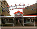
Barnsley Open market.
Once famed for its outdoor market, Barnsley awaits regeneration.
Image: © Steve Fareham
Taken: 2 Aug 2007
0.07 miles
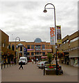
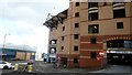
4
Walking on the Mall
The open deck of The Mall shopping centre car park in Barnsley with the Town Hall in the background.
Image: © Steve Fareham
Taken: 17 Feb 2010
0.07 miles
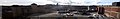
5
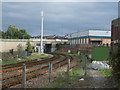
Railway towards Sheffield
Looking south east from the level crossing on Kendray Street.
Image: © JThomas
Taken: 27 Sep 2014
0.07 miles

9
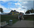
Pedestrian underpass leading to Doncaster Road, Barnsley
Image: © Steve Fareham
Taken: 17 Sep 2011
0.09 miles
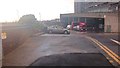
10
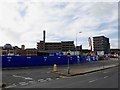
Hoardings around the former CEAG factory site Barnsley
Creating a new car park.
Image: © Steve Fareham
Taken: 16 Nov 2015
0.09 miles