IMAGES TAKEN NEAR TO
Pitt Street, BARNSLEY, S70 1AW
Introduction
This page details the photographs taken nearby to Pitt Street, S70 1AW by members of the Geograph project.
The Geograph project started in 2005 with the aim of publishing, organising and preserving representative images for every square kilometre of Great Britain, Ireland and the Isle of Man.

There are currently over 7.5m images from over14,400 individuals and you can help contribute to the project by visiting https://www.geograph.org.uk
Image Map
Images are licensed for reuse under creativecommons.org/licenses/by-sa/2.0
Notes
- Clicking on the map will re-center to the selected point.
- The higher the marker number, the further away the image location is from the centre of the postcode.
Image Listing (207 Images Found)
Images are licensed for reuse under creativecommons.org/licenses/by-sa/2.0
Image
Details
Distance
2
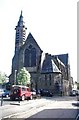
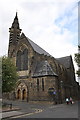
Church of the Holy Rood, Castlereagh Street, Barnsley
Image: © Bill Henderson
Taken: Unknown
0.05 miles
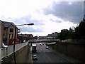
4
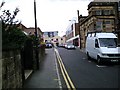
Pitt Street - viewed from Wellington Street
Image: © Betty Longbottom
Taken: 25 Mar 2017
0.07 miles
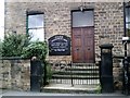
5
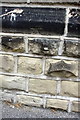
Benchmark on Holy Rood Church
Ordnance Survey cut mark benchmark described on the Bench Mark Database at http://www.bench-marks.org.uk/bm39222
Image: © Roger Templeman
Taken: 13 Aug 2011
0.07 miles
9
Progress 2011
Demise of the Old Pioneer Store, about to become a Lidl.
Image: © Barry Potter
Taken: 1 Mar 2011
0.08 miles
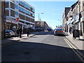
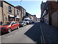
10
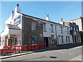
The Shakespeare - Wellington Street
Image: © Betty Longbottom
Taken: 25 Mar 2017
0.08 miles